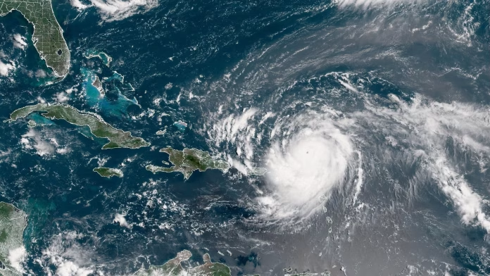
Hurricane Erin strengthened rapidly over the Atlantic just north of the Caribbean on Saturday. It turned from a tropical storm into a major hurricane in a single day, bringing heavy rain and strong winds to the islands.
Erin became the first Atlantic hurricane of 2025. It reached Category 5 before easing slightly to Category 4, with maximum sustained winds of 220 kilometres per hour, according to the National Hurricane Center in Miami.
Late on Saturday, the storm’s centre was “undergoing structural changes” but remained “formidable” as rain and winds affected Puerto Rico and the Virgin Islands.
The hurricane moved west-northwest at 22 kph, roughly 230 kilometres north-northeast of San Juan, Puerto Rico. Meteorologists said it was unlikely to make a direct landfall.
Mike Brennen, director of the Hurricane Centre, said Erin’s winds had increased by 96 kph in about nine hours. Forecasters expect it to remain a major hurricane in the coming week.
Precautionary measures and local response
Although the storm is forecast to pass north of Puerto Rico, heavy rainfall could trigger flash floods, landslides, and mudslides. Tropical storm watches cover St. Martin, St. Barts, and the Turks and Caicos Islands.
The National Weather Service in San Juan warned nearly two-thirds of Puerto Rico about 80 kph winds on Saturday night. Officials advised people to shelter in secure buildings. Around 130,000 residents lost power across the territory.
Earlier in the day, life in the Puerto Rican capital continued as usual. Locals and tourists walked, shopped, and exercised. Restaurants stayed busy. Some people went into the water despite warnings, but children were kept out.
Visitors Sarahi Torres and Joanna Cornejo from California went to the beach to wade in for a Bad Bunny concert, saying the skies looked calm.
The US government deployed over 200 staff from the Federal Emergency Management Agency and other agencies. Puerto Rico’s Housing Secretary, Ciary Perez Peña, said 367 shelters had been inspected and were ready to open. Officials in the Bahamas also prepared shelters and advised residents to monitor the storm closely.
Historical context and climate implications
Forecasters warned that strong rip currents could reach the US East Coast from Florida to the mid-Atlantic next week, even though the hurricane’s eye is expected to stay offshore.
Hurricane specialist Michael Lowry called Erin’s rapid intensification “incredible for any time of year, let alone mid-August.” He noted that only four other Category 5 Atlantic hurricanes have occurred before 16 August.
Hurricanes usually peak later in the season, around mid-September. Past examples include Hurricane Wilma in October 2005, which became Category 5 in under 24 hours before weakening to Category 3 prior to hitting Florida, and Hurricane Felix in October 2007, which reached Category 5 in just over a day.
Including Erin, the Atlantic has recorded 43 Category 5 hurricanes. Dan Pydynowski, senior meteorologist at AccuWeather, said these storms are rare, though this marks the fourth consecutive year with a Category 5 hurricane in the basin. He explained that warm seas, low wind shear, and distance from land help storms reach this strength.
Scientists link rapid hurricane intensification to climate change. Rising temperatures increase atmospheric water vapour and ocean heat, providing energy for faster strengthening and heavier rainfall.
Rapidly intensifying storms complicate forecasts and emergency planning. Hurricane Erick in the Pacific doubled in strength in less than a day before hitting Oaxaca, Mexico, on 19 June.
Erin is the fifth named storm of the 2025 Atlantic hurricane season, which runs from 1 June to 30 November. Forecasters predict six to ten hurricanes this season, with three to five becoming major storms with winds over 177 kph.
